Main Content
Steve Yergeau, Rutgers Cooperative Extension
Love is in the air! If you are interested in creating a lasting relationship with native plants in your yards and gardens, you should ensure that they feel the love in the soil and water, too. To confirm that your native plants are appropriate for your area, you can use ecoregion maps to select them and show them the love they need to thrive.
What are ecoregions?
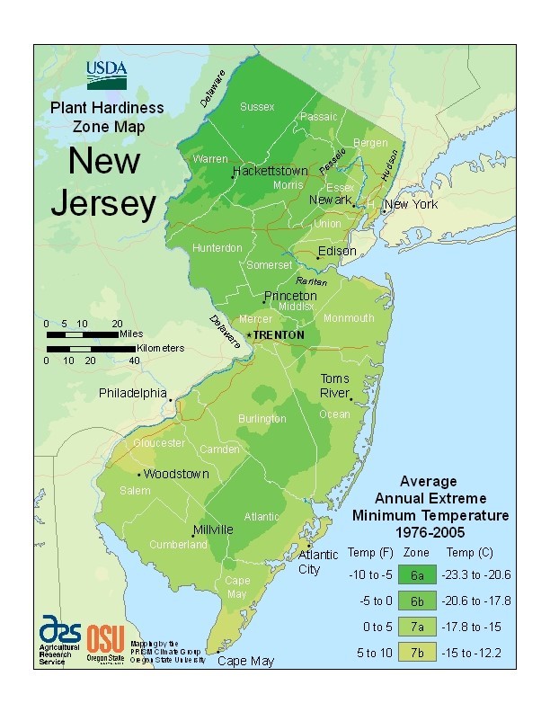
Ecoregions are areas in local ecosystems that have similar temperatures, precipitation, geology, soils, elevations, wildlife, plants, and other characteristics (www.epa.gov/eco-research/ecoregions). These areas are mapped to show where different species of plants are likely to be distributed, grow, and survive. Most people who garden are familiar with their Plant Hardiness Zone Map, which outlines locations in their state where plants ranked for that zone will survive (Figure 1). Their hardiness is solely based on the local average annual minimum winter temperature for that area. For example, New Brunswick in Middlesex County (NJ) is in Zone 7a where plants can tolerate temperatures as low as 0 to 5 °F (-17.8 to -15 °C). Hardiness zones were developed to help gardeners and landscapers know which exotic ornamental plants, vegetables, or other vegetation would survive freezing or winter injury to which they may not be accustomed (Widrlechner et al., 2012).
While winter temperatures have been shown to be a good determinant of a plant’s distribution across ecosystems, they do not tell a complete story for native plants. Just because a plant can survive a certain winter temperature doesn’t mean that it is native everywhere that temperature is found. Many factors go into determining a plant’s provenance in an ecosystem such as changing soil moisture levels, reduced or increased precipitation, and reduced exposure to sunlight. Ecoregion maps add in these factors to create a more complex picture of the local landscape and help determine the appropriateness of plants for a given area and whether they will survive or potentially be considered non-native or invasive.
How do ecoregion maps work?
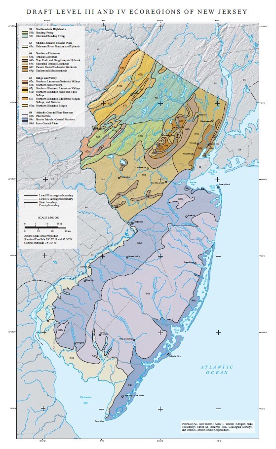
Ecoregions are divided into different “levels.” Those levels become more specific at smaller scales. For example, at Level I, North America is broadly divided into 15 ecoregions with most of the Eastern United States classified as ‘Eastern Temperate Forests’ (www.epa.gov/eco-research/ecoregions-north-america). Throughout this ecoregion there are many similarities including general climate, native plants, and native wildlife. However, there are also many differences especially in geology and soil characteristics (i.e., moisture, texture, pH). That is where the Level II, III, and IV ecoregion maps become useful – each one zooms in closer and provides more detail at a smaller scale. The Level III and IV Ecoregion Map for New Jersey, for instance, further divides the state into 17 ecoregions (Figure 2). These subdivisions include ‘Hackensack Meadowlands,’ ‘Pine Barrens,’ and ‘Triassic Lowlands’ that account for the differences that occur at this smaller scale.
The ‘Pine Barrens’ ecoregion, for example, is located along the southeastern portion of New Jersey (Figure 2) and extends along the East Coast past Long Island (NY) to Cape Cod (MA). This ecoregion is characterized by a climate affected by its proximity to the ocean (i.e., higher humidity) and its flat landscape. The soils can range from sand, silt, loam, and clay, but are generally poor at retaining water making these areas drier and more prone to fires. Forest cover is mostly pine-oak forest, with pitch pine being a dominant species. Closer to the coastline, unique woodland communities are found near dunes and in Atlantic white cedar swamps.
How can you use ecoregions in your native plant selection?
Ecoregion maps were developed to assist with managing local resources in a holistic manner (Omernik and Bailey, 1997). Homeowners can manage their yards and gardens as fine-scale ecosystems and ecoregion maps can assist with the selection of suitable native plants for their landscape. While there are resources available from Rutgers Cooperative Extension (njaes.rutgers.edu/fs1140/), Jersey-Friendly Yards (www.jerseyyards.org/jersey-friendly-plants/native-plants/) and the Native Plant Society of New Jersey (npsnj.org/native-plants/where-to-buy-natives/plant-lists/), these lists do not take ecoregions into account. A survey of native plant material users in the Eastern United States found that ecoregional species lists are the most desired type of technical document for plant suppliers and homeowners (Tangren et al., 2022).
Luckily, the National Wildlife Federation has developed native plant lists for those interested in basing their native plant selection on ecoregion. A list for important, keystone plants (www.nwf.org/Garden-for-Wildlife/About/Native-Plants/keystone-plants-by-ecoregion) and for pollinator host plants (www.nwf.org/Garden-for-Wildlife/About/Native-Plants/Find-Available-Natives) are available through their website. Note that these plant lists are based upon the Level I ecoregion of ‘Eastern Temperate Forests’ and additional research may be needed to determine the native status of plants for your local area and in higher ecoregion levels (i.e., Level III and IV). In addition, the Jersey-Friendly Yards website’s database (www.jerseyyards.org/plant/) allows users to select special ecoregions, such as ‘Barrier Island/Coastal’ and ‘Pinelands’ when looking up native plants for one’s yard.
Resources
Ecoregions By State – www.epa.gov/eco-research/level-iii-and-iv-ecoregions-state
Click on a state’s name on the interactive map to find the Level III and IV ecoregion map for that state.
Plant Hardiness Zone Map – planthardiness.ars.usda.gov/
Enter your zip code to get which plant hardiness zone you are in and select vegetation that is suited to grow in that zone.
Jersey-Friendly Plant Database – www.jerseyyards.org/plant/
Search for native plants appropriate for New Jersey on this database, which includes information on the plant’s hardiness zone(s).
References
Omernik, J.M, and R.G. Bailey. 1997. Distinguishing Between Watersheds and Ecoregions. Journal of the American Water Resources Association. 33(5). pp.935-949.
Tangren, S., E. Toth, and S. Siegel. 2022. A Survey of Native Plant Materials Use and Commercial Availability in the Eastern United States. Native Plants. 23(1). pp.17-32.
Widrlechner, M.P., C. Daly, M. Keller, and K. Kaplan. 2012. Horticultural Applications of a Newly Revised USDA Plant Hardiness Zone Map. HortTechnology. 22(1). pp.6-19.

