Main Content
Douglas Zemeckis, Rutgers Cooperative Extension
“It’s a bird.” “It’s a plane.” “No, it’s a glider!” “What’s a glider?!?” “An underwater robot!”
Observing the ocean is inherently difficult whether it is close to shore or hundreds of miles from land. The ocean is so vast and it can cost more than $75,000 per day for an oceanographic vessel with a scientific crew to go out and directly measure the ocean. As a result, oceanographers employ advanced autonomous technologies such as satellites or gliders (“underwater robots”) to remotely observe our oceans and help understand marine life.
The information gained through measurements recorded by technologies such as gliders helps to better understand the physics, chemistry, biology, and geology of the ocean. These data are used for water quality and beach monitoring, fisheries science and management, hurricane forecasting, search and rescue at sea, understanding climate change impacts, and so much more!
Data recorded by gliders are often made widely available so that the general public, scientists, managers, and other stakeholders can access them to use in their personal or business lives. This Earth Day, Every Day program’s monthly newsletter article for February 2024 will describe gliders, how they are used to monitor the ocean off New Jersey, and some of the applications to marine life and human uses of the coastal ocean.
What Are Underwater Gliders?
Oceanographers often observe the ocean by using underwater gliders (Figure 1), or Slocum Autonomous Underwater Vehicles (AUVs) built by Teledyne Webb Research Corporation (Falmouth, MA). Rutgers University’s Center for Ocean Observing Leadership (RUCOOL) maintains a large fleet of gliders that they use for observing the ocean off the New Jersey coast and all around the world — including frequent expeditions in Antarctica or even tracks across the whole Atlantic Ocean that went from New Jersey to Spain!

Figure 1 – Researcher deploying a glider for an ocean observing mission (left) and a glider starting a downward dive to record oceanographic measurements (right). Photos from Rutgers University’s Center for Ocean Observing Leadership (RUCOOL).
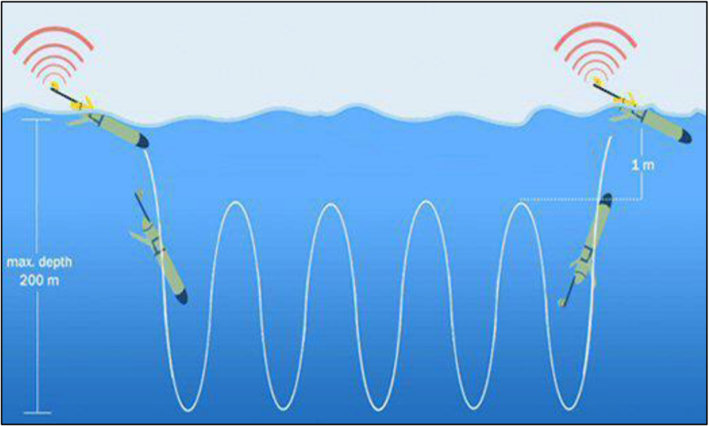
Underwater gliders can operate in nearshore ocean waters (~15 feet deep) out to distant offshore waters while recording measurements from the sea surface down to about 3000 feet deep. They regulate their buoyancy with a ballast engine that takes water in and out of their nose, which causes them to sink and then float as their buoyancy changes and the wings allow for a forward heading in a sawtooth or yo-yo pattern (Figure 2). Gliders have a pre-programmed mission to meet research objectives and they periodically come to the sea surface and communicate in real-time with researchers back on land via a satellite link. During these check-ins at the sea surface, scientists can look at the data collected, confirm that the glider is functioning properly and modify the mission, if needed.
Gliders can take a wide range of measurements during their missions depending on what types of sensors are installed. Standard oceanographic measurements include temperature, salinity (i.e., measure of dissolved salts in water), dissolved oxygen, and depth. More advanced sensors can be attached to do things such as measure chlorophyll concentration to record data on microscopic plants in the ocean (i.e., phytoplankton), record measurements of ocean pH to study ocean acidification, listen for sounds produced by fish or marine mammals (e.g., the robots4whales program) to better understand their behaviors, and track tagged fish to identify preferred habitats. As you can see, gliders are a valuable tool and can be considered the Swiss Army knife of ocean observing!!

Figure 2 – Depiction of a glider making a sawtooth or yo-yo pattern while collecting oceanographic measurements in the top 200 meters (~650 feet) of the ocean and communicating with scientists back on land via satellites at the sea surface. Image adopted from the National Oceanography Centre in England.
How Are Gliders Used off New Jersey?
Researchers from RUCOOL use gliders to answer many scientific questions related to New Jersey’s marine ecosystems and resources – active RU glider deployments can even be tracked in real-time! The following are some common applications where gliders are being used to study the coastal ocean off the Garden State:
Coastal Water Quality Monitoring: Gliders have been deployed in the coastal ocean off New Jersey in collaboration with the New Jersey Department of Environmental Protection for more than a decade to monitor water quality parameters, such as temperature, salinity, dissolved oxygen, chlorophyll, and depth. Dissolved oxygen has been a particular focus of much of the work off New Jersey since our ocean waters were identified as impaired for dissolved oxygen back in 2002. In fact, glider deployments by RUCOOL researchers in 2023 observed unusual ocean conditions with very low dissolved oxygen levels in the ocean waters off our coast that could have been linked to the observed mortality in several species (black sea bass, tautog, lobsters) noticed that summer by commercial fishermen.
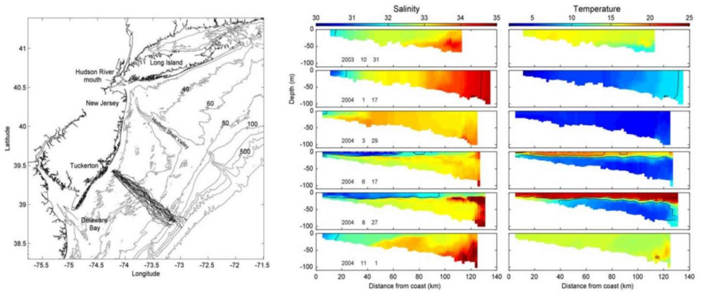
Glider deployments also help to understand how the salinity and temperature change by season, depth, and distance from shore (Figure 3 – left panel). Water is more dense and heavier when it is saltier (i.e., higher salinity) or colder. Therefore, these data from glider observations show the stratification (i.e., layering) in the ocean with waters of different salinity and temperature (and therefore different densities) (Figure 3 – right panel). Observations of these dynamics are key to our understanding of local water temperatures, currents, and sea breezes given the interactions between the ocean and atmosphere.

Figure 3 – Shows glider deployment tracks going from Tuckerton, NJ to the edge of the continental shelf (left) completed by Castelao et al. (2008) to investigate how salinity and temperature change seasonally (right) as you go further offshore during October, January, March, June, August, and October (right – top to bottom rows). The salinity scale shows increasing salinity from blue to red, while the temperature scale shows increasing temperature from blue to red. Note generally colder and saltier waters at the bottom and stratification during summer with strong differences at the sea surface versus the bottom.
These dynamics can help determine what the temperature might be at your favorite beach during the summer. For example, have you ever been to the beach on a hot summer day and the water was surprisingly frigid? This is likely due to coastal upwelling where local conditions result in cold bottom waters being pushed up onto the beach. The direction of the wind makes a huge difference in whether the warm surface waters stay close to the beach or get pushed offshore and allow the cold bottom water to be pushed onto the beaches. In addition to RUCOOL’s glider data, they also have satellite data that you can access free online, which can help you decide which beach will have warmer water and might be a better place to visit and swim!
Hurricane Science: As introduced above, the ocean and atmosphere are connected and they interact to influence hurricanes. Oceanographic observations near and within hurricanes wouldn’t be possible by ships given the stormy conditions during hurricanes. Therefore, gliders present a unique opportunity to collect valuable oceanographic observations during these storms to aid in improving forecast accuracy and lead times, and to have more timely and effective storm responses.
RUCOOL researchers have been at the forefront of using gliders to observe oceanographic conditions for improving our ability to understand hurricanes and improve forecasting. More information about their works are available on the following webpages: Hurricanes & Extreme Weather and Hurricane Presentations.
Fish and Fisheries: Commercial and recreational fishing are critical industries for our state’s economy, the culture of the Jersey Shore, and for producing food for local, national, and international markets. The survival and growth of the finfish and shellfish caught in these fisheries rely on suitable water quality conditions. For example, shellfish such as sea scallops and surfclams prefer cold, deep water off our coast that is often part of the Mid-Atlantic Cold Pool. And, highly migratory species such as tunas, swordfish, and many shark species, visit the Jersey Shore during the warm summer months and can be linked to the warm Gulf Stream waters. Gliders are one tool that RUCOOL researchers and colleagues use to better understand our coastal ocean and the habitats used by marine species, including the Cold Pool and Gulf Stream and the implications for the sustainability of our fisheries and fishing communities.
Offshore Wind Energy Development: Responsible development of offshore wind energy off New Jersey and elsewhere in the northeast requires a solid understanding of the oceanography of our coastal ocean, including how the ocean and atmosphere vary and interact. Fortunately, RUCOOL and colleagues have taken the lead in pioneering research in ocean observing for more than 30 years and we therefore have valuable data to aid in informing offshore wind energy development off New Jersey based on these many years of research and continued work. Check out the following resources to learn more about research by RUCOOL and colleagues related to offshore wind energy: Rutgers Offshore Wind Living Resources Studies.
Acknowledgements
Thanks to other members of our Earth Day, Every Day team for their feedback on a draft of this article, including Steve Yergeau, Amy Rowe, Michele Bakacs, and Sal Mangiafico. Also, thank you to Grace Saba, Kaycee Coleman, Travis Miles, and Josh Kohut from the Rutgers University Center for Ocean Observing Leadership (RUCOOL) for their helpful edits and input regarding gliders and ocean monitoring.